

In this article, we explain what is surveying in civil engineering, what are the different purposes of surveying, the various principles of surveying, the different uses of surveying, types of surveying and classification of surveying and so more.
so please read the article till the end. If you find any problem in this article please comment us.
Table of Contents
What is Surveying in Civil Engineering?
The art of determining relative positions of various points, above or below the surface of the earth’s, is called surveying.
This is determined by taking measures such as the relative positions of the various points, their distance, direction, and height.
These measurements are linear or angular.
What is Levelling in civil engineering:
Leveling is a branch of surveying in which the relative heights of various points from the datum to the surface of the earth are determined.
Simply,
Surveying is the act of determining the relative position of different points in a horizontal plane.
Surveying Definition
Where,
Levelling is the act of determining the relative position of various points in a vertical plane.
Leveling Definition
Purposes of Surveying in Civil Engineering:
The objectives of the surveying are as follows.
- To determine the extent and area of farms for collection of tax from the land.
- To determine the alignment of roads, railways and to know the quantity of cutting & filling in the construction area.
- To know the topography of the ground surface before the construction of a dam. Based on that we are able to know how much water will accumulate in the lake, how much area will be submerged when the lake is formed, and how many villages will have to be relocated.
- For the Planning of canals, water supply pipelines, sewers, tunnels, etc, Surveying is necessary.
- To make a plan to show the relative position and depth of various objects on the surface of the earth.
- To calculate area and volume.
Uses of the surveying in civil engineering:
- Surveying is used To create a topographical map showing the natural features of the country such as rivers, mountains, lakes, hills, valleys, forests, etc.
- Surveying is used to create a cadastral map showing the boundaries of farms and plots.
- Surveying is used to create a contour map to decide an appropriate location for the dam, canal, building, road, railway, bridge, etc.
- Surveying is used to decide the alignment of roads, railways, canals, tunnels, electric lines, sewer lines, water lines, bridges, etc.
- Surveying is used to draw an uneven boundary of the plot on a map.
- Surveying is used to determine the specific gradient for water lines, sewers, roads, etc.
- Surveying is used to determine the quantity of minerals in the earth’s crust through a mining survey.
Principles of surveying in civil engineering
The following principles should be kept in mind to maintain accuracy during the survey.
- Working from whole to part
- Location of a point by measurement from two points of reference.
1. Working from whole to part:
As per this principle of surveying, the framework of surveying should be prepared by accurately fixing the relative position of the control point (away point from surveying area) on the surveying area.
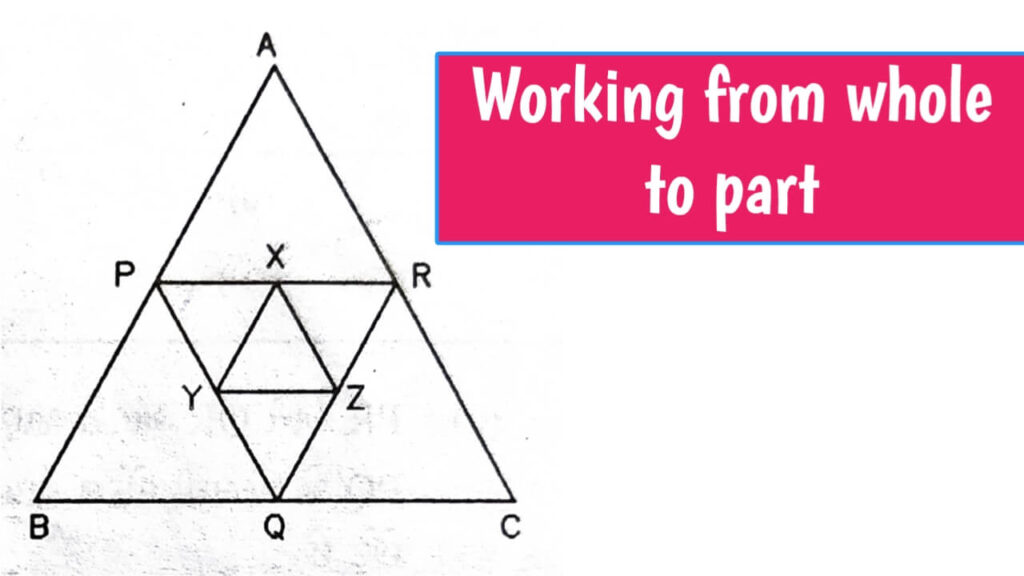
- A, B, C = Control points
- P, Q, R, X, Y, Z = Minor control points
- ∆ABC = Main framework
- ∆XYZ = Subsidiary framework
This type of triangle is called primary traverse or main frame work. Such triangles are wide.
These sub frameworks PQR and XYZ can be quickly established with relatively low accuracy by taking main framework ABC as a base.
Then surveying of interior parts can be done with less accuracy and speed.
By doing this, the errors that occur during the survey can be localized enough and the accumulation of errors can be avoided. That is, the error stays within limits, it does not increase.
Conversely, if the first small framework XYZ is surveyed and expanded to form the larger framework ABC, the defects in the smaller structure become much larger as the larger framework surveys.
2. Location of a point by measurement from two points of reference:
According to this principle, two other known points are used to determine the location of a new point on the field.
Suppose P and Q is two known points on the ground. The distance between these two points is measured with PQ accuracy and drawn on a sheet of paper with the appropriate scale. The location of the other third point R is determined as follows.
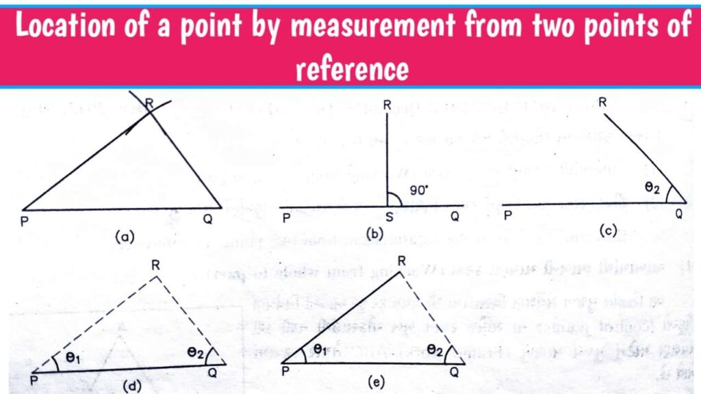
a. PR and QR distances are known.
Two arcs PR and QR are drawn from the scale from which PQ is drawn. At crossing of these two arc is R points.
This principle is useful in chain surveying.
b. Locations P and Q are known.
RS perpendicular to the PQ line from point R is drawn. Length is measured PS and SR. Point R is then plotted using set squares. This principle is useful for defining information.
c. Distance QR and angle PQR are known. With which point R can be plotted.
This principle is useful in traversing.
d. Angles RPQ and RQP are known.
The line is drawn at point P at Angle RPQ and at point Q at angle RQP. The point R obtained by crossing of these two lines.
This principle is useful for triangulation.
e. Angle RQP and length PR are known.
Point Q ahead, the angle RQP at which the line is drawn. A point is obtained by taking an arc with a radius equal to PR from the point P.
This principle is useful in traversing.
Types of Surveying in civil engineering:
Surveying can be divided into two main categories:
- Plane surveying
- Geodetic surveying
Understanding these type of survey by differences.
Difference between Plane survey and Geodetic survey.
| Plane Surveying | Geodetic Surveying |
|---|---|
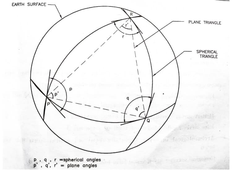
| Plane surveying is a type of survey in which the surface of the earth is assumed to be plane or flat. The roundness of the earth is ignored. | Geodetic Surveying is a type of survey that takes into account the globular surface of the earth. |
| All survey lines are considered straight and all triangles are assumed to be flat. All plumb lines are assumed to be parallel. | All survey lines are considered curved and all triangles are considered spherical triangles. |
| Useful for measuring small distances and small areas. Useful For areas less than 250 km2 | Useful for measuring large distances and wide area. For areas over 250 km2 |
| The degree of accuracy is low. | The degree of accuracy is very high. |
Classification of surveying in civil engineering:
Surveying can be classified Based on
- The nature of the field
- Object of survey
- Instrumental Based
1. Classification based upon the nature of the field survey:
Land survey:
There are three types of land survey.
1. Topographical survey:
Topographical survey is used to determine natural features such as rivers, lakes, forests, hills etc.
It is also used to locate artificial features such as roads, railways, canals, cities, villages etc.
2. Cadastal survey:
Cadastal survey is used to fixing the boundaries of various place, location. Like
- It is used to determine the property line,
- It is used to calculate the area of various places location.
- It is used to determine the boundaries of states and municipalities.
3. City survey:
City survey is useful for construction of city roads.
- It is carried out for laying and construction water supply pipeline
- It is used for the construction of sewer lines.
2. Marine or Hydro graphic survey:
As per name, its explain its purpose like,
- It is used for measuring the discharge of a river.
- Survey of the coast and river banks.
- For Measuring the depth of the sea.
2. Classification based on object of survey:
1. Engineering survey:
This type of survey is done to get quantity and other information for engineering works like roads, reservoirs, water supply, sewer lines etc.
2. Military survey:
Military surveys are conducted to determining points of strategic importance.
3. Mine survey:
Mine survey is done to find minerals in the soil.
4. Archaeological survey:
Archaeological survey is performed to find antiquities and relics.
5. Geological survey:
Geological survey is carried out to obtain information about the various layers in the earth’s crust.
3. Classification based on instrument used:
- Chain survey
- Traverse survey
- Triangulation survey
- Compass survey
- Theodolite survey
- Tacheometric survey
- Photographical survey
- Aerial survey
- Plane table survey

I am a Professional Civil & Structural Engineer having more than 4 years of experience in Engineering, Procurement and Construction industry. Here i sharing the latest updates of EPC Projects and Construction News.